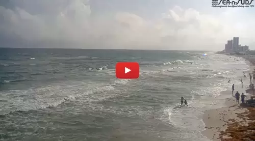
Track real-time coastal surf breaks, open-ocean swell paths, and beachfront crowd density across the Alabama Gulf Coast instantly. This high-definition network camera offers a continuous streaming view over the white-sand shoreline of Gulf Shores, capturing immediate wave configurations, tidal changes, and maritime conditions throughout Baldwin County.
Whether you are a surfer checking morning wave shapes and nearshore wind shifts, an angler evaluating current water movement off the coastal sandbars, or a beachgoer tracking fast-moving Gulf storm cells, this active digital viewport serves as your real-time maritime radar.
Beachfront Surveillance from the Sea N Suds Boardwalk
Positioned directly on the shoreline corridor, this prime visual vantage point delivers an uninhibited view of the open Gulf of Mexico. The streaming lens captures daily pedestrian traffic, changing sand configurations, and shifting maritime horizons, making it an indispensable fallback tool for checking dry sand parameters before driving to the coast.
Utilizing this active network frame allows virtual travelers to seamlessly evaluate real-time wave chop, lifeguard tower flags, and changing meteorological patterns prior to packing their gear.
🗺️ Live Camera Location Data
- Host Venue: Sea N Suds Boardwalk, Gulf Shores, AL
- Physical Address: 405 East Beach Boulevard, Gulf Shores, AL 36542
- Geographic Coordinates: 30.2471° N, 87.6814° W — Oceanfront restaurant pier tracking open Gulf surf and coastal weather variables.
Gulf of Mexico Coastal Meteorology & Swell Analytics
GULF SHORES WEATHERThe maritime climate framing the Alabama coast features dynamic subtropical attributes heavily dictated by open Gulf winds and seasonal deep-water pressure shifts:
- Tropical Storm & Surge Encroachment: During active tropical storm phases, the low-lying shoreline handles aggressive storm surges and heavy coastal wind shear velocity. Beachgoers rely on the live camera array to safely inspect sandbar stability and changing high-tide boundaries from a distance.
- Sudden Summer Convective Lines: Hot summer afternoons routinely spark rapid, high-intensity convective thunderstorm cells moving off the mainland. Checking the live stream offers an indispensable visual reference to track incoming wall clouds and verify clear skies before walking onto the open sand.
- Winter Wind-Shear Outbreaks: Brisk northern cold fronts drop down the coast during winter stretches, turning the open shoreline into a high-wind tracking zone. Use the webcam feed to confirm ambient lighting and wave chop before heading outdoors.
Top Regional Attractions & Things to Do Nearby
- Gulf State Park Pier: Walk or fish along a massive, nearby public pier structure extending 1,542 feet into the open Gulf waters, featuring dedicated angling decks and tackle stations.
- Hugh S. Branyon Backcountry Trail: Explore more than 28 miles of paved multi-use trails weaving through nine distinct coastal ecosystems, pristine maritime forests, and quiet swamps.
- Alabama Gulf Coast Zoo: Drive brief minutes inland to tour an acclaimed animal preservation sanctuary hosting global exotic wildlife species and immersive animal encounter programs.
- Orange Beach Waterfront District: Travel a short distance east down the coastal highway link to access premium marina charters, deep-sea fishing excursions, and seaside dining.
Quick Facts & Frequently Asked Questions
What main beach parameters does this live camera track?
The camera is strategically optimized to monitor open-ocean surf structures, breaking swells, and public beach foot traffic along the central East Beach Boulevard corridor.
Is public vehicle parking accessible near this camera site?
Yes. The beach corridor features public vehicle parking stalls, outdoor beach showers, public restroom facilities, and walkable boardwalk access ramps directly adjacent to the sand.
Where can I check official regional marine weather warnings and tide logs?
Live convective storm watches, maritime gale warnings, and daily high/low tide graphs are managed directly by the National Weather Service (NWS) Mobile forecast office.