Live Key West Webcams: Duval Street Crowds & Florida Keys Transit Portals

Observe the vibrant island traffic and changing maritime elements of the southernmost city in real time. This comprehensive index of live Key West webcams delivers 24/7, high-definition streaming views stretching from the historic downtown corridors to the outer bayside slips. Engineered as a centralized visual dashboard for daily commuters checking maritime transit routes, incoming vacationers scouting beach weather, and reef boaters monitoring wind shear velocity, this network provides direct verification of Duval Street crowd density, cruise port ship dockings, and Gulf of Mexico wave heights.
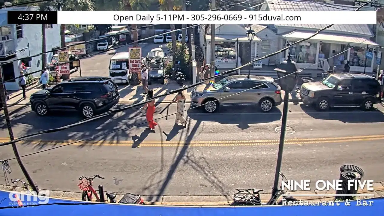
High-vantage hospitality infrastructure webcam view tracking the historic Victorian storefront exterior, open-air upper deck dining patio, and active pedestrian walkway lanes at Nine One Five on Duval Street in Key West, Florida. Live View: The Nine One Five Deck Webcam in Key West
Comprehensive municipal navigation layout map highlighting the strategic roadway grid, maritime ports, public beach preserves, and historic tourism landmarks of Key West, Florida. Florida Straits Navigation Spine: Interactive Map of Key West Florida
High-vantage maritime infrastructure webcam view tracking floating luxury yacht slips, active catamaran excursion berths, historic tall ship rigging lines, and open harbor water horizons at the Key West Bight Marina in Florida. Live View: Key West Bight Marina Webcam – Historic Seaport
High-vantage indoor hospitality infrastructure webcam view tracking white-tablecloth restaurant seating, the bar lounge area, historic storefront window overlooks, and passing pedestrian traffic on Duval Street in Key West, Florida. Old Town Entertainment Spine: Live La Trattoria Duval Street Webcam
La Trattoria Oceanside - Key West, Florida Atlantic Littoral Horizon: Live La Trattoria Oceanside Webcam
Marker Hotel Key West Webcam - Live Video | Florida Florida Straits Navigation Spine: Interactive Map of Key West Florida
High-vantage municipal grid webcam matrix view tracking heavy pedestrian sidewalk traffic, scooter parking rows, storefront awnings, and colorful historic architecture along the main commercial spine of Duval Street in Key West, Florida. Florida Straits Navigation Spine: Live Duval Street Cameras
High-vantage maritime landmark webcam view tracking the anchored concrete Southernmost Point buoy, visitor photo queues, the intersection of Whitehead and South Street, and the open ocean horizon facing Cuba at Key West, Florida. Florida Straits Navigation Spine: Live Southernmost Point Buoy Webcam
Live high-definition webcam streaming view of the outdoor pool deck, tropical palm trees, and traffic lanes of North Roosevelt Boulevard at the 24 North Hotel in Key West, Florida. Live 24 North Hotel Webcam: Key West Entry Corridor
Rick's Bar Key West Webcam | Live Video Live Rick’s Bar Key West Webcam: Duval Street Nightlife Corridor
High-vantage hospitality infrastructure webcam view tracking the indoor performance stage, live acoustic musicians, bar counter assemblies, and energetic patron crowds at Irish Kevin's Bar on Duval Street in Key West, Florida. Florida Straits Navigation Spine: Live Irish Kevin’s Webcam
High-vantage hospitality infrastructure webcam view tracking the resort swimming pool deck, lounging plazas, palm canopy lines, and open turquoise ocean horizons at the Southernmost Beach Resort in Key West, Florida. Florida Straits Navigation Spine: Live Southernmost Beach Resort Webcam
High-vantage maritime hospitality infrastructure webcam view tracking private boat docking slips, active houseboats, floating marina walkways, and open bay horizons at the Harborside Motel and Marina in Key West, Florida. Florida Straits Navigation Spine: Live Harborside Motel and Marina Webcam
High-vantage institutional infrastructure webcam view tracking public campus walkways, outdoor marine diving and research lagoons, student center plazas, and open ocean weather horizons at The College of the Florida Keys in Key West, Florida. Lower Keys Educational Axis: Live The College of the Florida Keys Webcam
High-vantage internal glass-enclosed botanical conservatory infrastructure webcam view tracking multi-colored free-flying butterfly species, tropical flora canopies, and lush nature gardens at Key West, Florida. Florida Straits Navigation Spine: Live Key West Butterfly Conservatory Webcam
Live streaming webcam view of the historic entrance and pedestrian sidewalks outside Sloppy Joe's Bar on Duval Street in Key West Florida. Live View: Sloppy Joe’s Bar Webcam – Key West Street Level & Entertainment Cam
High-vantage hospitality infrastructure webcam view tracking the open-air Sunset Pier boardwalk planks, overwater dining benches, commercial catamaran berths, and expansive Gulf of Mexico horizons at Ocean Key Resort in Key West, Florida. Florida Straits Navigation Spine: Live Ocean Key Resort Webcam
• Live streaming webcam view of the shipping channels and public beach area at Fort Zachary Taylor Historic State Park in Key West Florida. Live View: Fort Zachary Taylor Historic State Park Webcam – Key West Beach & Shipping Channel Gateway
Live streaming webcam view of the open-air bar layout and harbor boardwalk at Schooner Wharf Bar in Key West Florida. Live View: Schooner Wharf Bar Webcam – Historic Key West Seaport
The Green Parrot Bar Live Webcam - Key West, Florida Live Green Parrot Bar Webcam: Key West Entertainment Axis
Live high-vantage harbor webcam view of mega-cruise liner docks, the Sint Anna Bay style deep shipping lanes, and marine weather lines from Key West, Florida. Live Key West Port Webcam: Florida Straits Shipping Corridor
High-vantage indoor-outdoor hospitality infrastructure webcam view tracking the open-air dining patio, live acoustic guitar performance stage, and pedestrian walkway lines at Two Friends Patio in Key West, Florida. Florida Straits Entertainment Hub: Live Two Friends Patio Webcam
High-vantage indoor-outdoor hospitality infrastructure webcam view tracking multi-angle live performance stages, the outdoor courtyard patio bar, and tourist foot traffic at Hog's Breath Saloon in Key West, Florida. Hog’s Breath Saloon Webcam: Key West Live Stage & Patio Tracker
Live streaming webcam view of the open-air courtyard restaurant and dollar-bill-lined pillars at Willie T's bar on Duval Street in Key West. Willie T’s Restaurant & Bar Webcam: Key West Live Duval Street Tracker

Conch Architecture, Marine Basins, and Tropical Storm Frontiers

Navigating the bustling streets and high-volume harbors of this historic coral archipelago requires instant access to clear, unvarnished visual data. Looking through our active island camera matrix, drivers can check for pedestrian gridlock outside popular local eateries or evaluate fast-moving tropical rain bands rolling over the Florida Straits before setting sail.

Life along this low-lying territory revolves entirely around shifting seasonal weather fronts and tidal fluctuations. Having an eye-on check eliminates the guesswork. Whether you are tracking daily vehicle velocity near the Mile Marker 0 sign, checking the public staging lines at the Key West Express ferry docks, monitoring charter yacht arrivals at the Bight Marina, or analyzing reef visibility parameters across the Florida Keys National Marine Sanctuary, this directory keeps you connected to current conditions.

  • The Duval Street Strip: High-angle camera viewports tracking sidewalk crowds, nightlife foot traffic, and historic retail fronts outside local cafes.
  • The Bight Marina & Harbor Basins: Marine-facing lenses displaying real-time boat slip availability, sportfishing charters, and waterfront dock operations.
  • The Cruise Port Transit Gates: Continuous lookouts monitoring international passenger ship arrivals, custom plaza foot traffic, and deep-water shipping lanes.
  • The Stock Island Waterfronts: Specialized sub-stations tracking commercial shrimp boat docks, back-bay channels, and local marina bar atmospheres.

Regional Maritime Infrastructure & Navigation

Our Florida Keys tracking matrix aligns its primary visual check points along the narrow island chain, making it simple to map out local driving and boating routes.

  • Central Duval Street Coordinates: 24°33’14.2″N 81°47’43.5″W (24.5539° N, -81.7954° W)
  • Primary Island Transportation Axes: US Highway 1 / Duval Street / Whitehead Street
  • Central Marine Gateway: Key West Bight Channel / Cruise Liner Berth 1

Using these strategic geographic anchors allows offshore anglers to efficiently track weather blocks shifting south from Marathon, analyze road safety parameters along the Overseas Highway, or plan transit routes navigating toward the Dry Tortugas boat terminals.


Island Climate Guide: Rush Hour Crowd Surges & Tropical Storm Watch

KEY WEST WEATHER

A distinct tropical marine climate heavily moderated by the warm currents of the Gulf of Mexico and the Atlantic Ocean shapes this island, bringing breezy, sun-drenched winters and wet summer storm windows.

  • The Sunset Celebration Surge: Tune into the local harbor and plaza feeds daily during the late afternoon hours to watch tourist crowds gather along the western waterfronts, catch the famous golden hour light, and verify clear horizon lines.
  • The Hurricane Season Scan: Monitor the ocean-facing lookouts closely from June through November. When convective weather systems roll over the straits, these hardened lenses offer critical, real-time views of incoming shelf clouds, coastal storm surges, and changing wind chop.

Frequently Asked Questions

Why do travelers use these live Key West webcams?

Because tropical weather, sudden rain bands, and heavy tourist crowds can shift island conditions within a matter of minutes, local motorists and vacationers use this live directory to instantly verify actual street-level visibility and harbor conditions before heading out.

How can I check ferry schedules to Fort Myers Beach?

While our camera network provides direct visual confirmation of the local docks, visitors can utilize the Key West Express ferry terminal lookouts to track vessel loading and gate arrivals for transits heading north to Fort Myers or Marco Island.

Are these tropical camera streams active during severe weather?

Yes. The entire regional camera matrix is built on hardened outdoor infrastructure designed to stream 24/7 year-round, serving as a critical safety resource for the community to monitor live beach erosion, gale-force winds, and storm surges.